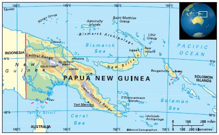
Geography of Papua New Guinea
Area: 462,840 sq km
Coastline: 5,150km
Capital: Port Moresby
The Independent State of Papua New Guinea in the South Pacific shares a land-border with Indonesia; its other near neighbours are Australia to the south and Solomon Islands to the east.
Papua New Guinea includes the eastern half of the world’s second biggest island, New Guinea, bordering the Indonesian province of Irian Jaya to the west. The rest of the country is made up of about 600 small islands, the chief of which are the Bismarck Archipelago, the Trobriands, the Louisiade Archipelago, the D’Entrecasteaux Islands, and some of the islands in the Solomons group, including Bougainville.
The country comprises 22 provinces including the National Capital District (greater Port Moresby) and the Autonomous Region of Bougainville.


