

Geography of Kiribati

Area: 811 sq km 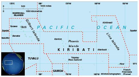
Coastline: 1,140km
Capital: Tarawa
Kiribati (pronounced ‘Kirabas’) spreads across the central Pacific, intersected by the equator and formerly the International Date Line, with most other Commonwealth Pacific island countries lying to its south. Its 33 islands are scattered across 5.2 million sq km of ocean. There are three groups of islands: 17 Gilbert Islands (including Banaba), eight Line Islands and eight Phoenix Islands. The north/south extent is 2,050km. Kiritimati (formerly Christmas Island) is the world’s biggest coral atoll (388 sq km). Kiritimati in the east is about 3,780km from Banaba (formerly Ocean Island) in the west.