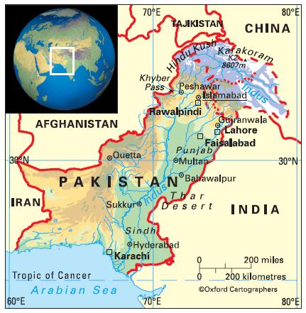
Geography of Pakistan
The designations and the presentation of material on this map, based
on UN practice, do not imply the expression of any opinion
whatsoever on the part of the Commonwealth Secretariat or the
publishers concerning the legal status of any country, territory or area,
or of its authorities, or concerning the delimitation of its frontiers or
boundaries. There is no intention to define the status of Jammu
and/or Kashmir, which has not yet been agreed upon by the parties.
Currency: Pakistan rupee (PRs)
Area: 796,095 sq km
Coastline: 1,050km
Capital: Islamabad
Pakistan lies just north of the Tropic of Cancer, bordering (clockwise from west) Iran, Afghanistan, China and India. The Arabian Sea lies to the south.
The country comprises four provinces: (from south to north) Sindh, Balochistan, Punjab and Khyber Pukhtoonkhwa (formerly North-West Frontier Province). The territory adjoining Khyber Pukhtoonkhwa is known as the Federally Administered Tribal Areas and the Pakistani-administered parts of Jammu and Kashmir in the north-east as Azad Kashmir and Northern Areas.
The designations and the presentation of material on this map, based on UN practice, do not imply the expression of any opinion whatsoever on the part of the Commonwealth Secretariat or the publishers concerning the legal status of any country, territory or area, or of its authorities, or concerning the delimitation of its frontiers or boundaries. There is no intention to define the status of Jammu and/or Kashmir, which has not yet been agreed upon by the parties.


