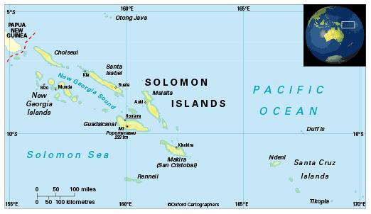
Geography of Solomon Islands
Area: 28,370 sq km
Coastline: 5,310km
Capital: Honiara
Solomon Islands, an archipelago in the south-west Pacific, consists of a double chain of rocky islands and some small coral islands. The major islands are Guadalcanal, Choiseul, Santa Isabel, New Georgia, Malaita and Makira (or San Cristobal). Vanuatu is the nearest neighbour to the south-east where the archipelago tapers off into a series of smaller islands. Its nearest neighbour to the west is Papua New Guinea.
The country comprises the capital territory of Honiara and nine provinces, namely Central (provincial capital Tulagi), Choiseul (Taro Island), Guadalcanal (Honiara), Isabel (Buala), Makira and Ulawa (Kirakira), Malaita (Auki), Rennell and Bellona (Tigoa), Temotu (Lata), Western (Gizo).


